| Maps
and Geography |
|
Update
History
Home
Background
& History
Updated 5/09!
Photographs
Maps and Geography
Updated 5/09!
The
Book
Your
Comments and Thoughts
Poetry
Printings
and Editions
References
to the Book
Links
Who
Are We?
Dedications
Email
Us!

|
 his
page provides maps and other geographical information about the area in
which the Vanderbecks lived and trapped, and in which Trap-Lines
North takes place. his
page provides maps and other geographical information about the area in
which the Vanderbecks lived and trapped, and in which Trap-Lines
North takes place.
The Nakina Heritage Waterway now encompasses Twin Lakes, the Drowning,
Wababimiga and Squaw rivers, up to the Little Current River Provincial
Park. It will also include Cordingley Lake and Twin Lakes as access points
to the waterway. This system was developed to provide a recreational,
historical, and an eco-tourist destination. You can go to the Community of
Nakina web site's Recreation/
Leisure page for more information.
|
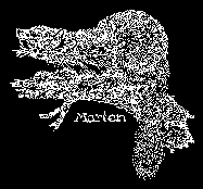
Map
of the Vanderbeck
Traplines
Full Size Map:
| Original Map (215K)
| Annotated with New Names
| (215K)
Small Map:
| 800 x 600 (25K)
| Color Version (38K) |
These are different size images made from the map that was printed on the inside cover of the
original printing of the book. This map is believed to be (or to be based
on) the map that Meader drew during his canoe trip with Jim, as described in the book's
Forward. It shows all of the Vanderbecks' camps and traplines described in
the book.
The names of many of the lakes and rivers mentioned in the book have
changed since then. The old and new names are listed
further down this page. We have annotated one version of the map with the
new names. Hopefully this will be of interest to anyone who would like to visit this
area and retrace the Vanderbecks' routes.
You may not be able to read all text on the 800 x 600 version, but it
is all readable on the full-size version. There is also a version
that has been colorized.
To view the map in your browser, left-click one of the links above. It
will launch in a new window. To return to this page, just close that
window.
To download the map to your hard drive, right-click the link and select 'Save
as.'
|
|
|
Map of 1931 Vanderbeck Canoe Expedition| Hand
Drawn Map (247 K)  |
|
This is truly a treasure! The link above launches an Adobe Acrobat document containing a scan of an
actual hand-drawn map produced by R.S. Sturgis, a member of a canoe trip led by Jim and
Lindsay Vanderbeck from August 23 to September 9, 1931. It shows 232-1/8
mile route that includes 16 camps and 41 portages. The route leaves
Nakina, traveling the Eskagganega, Little Current, Squaw, Cranberry
Rivers, and Cordingley, Poplar, and Grave and Squaw Lakes. It
includes stops at Jim's main camp on Squaw Lake, other Vanderbeck line
camps, the site of the watch grave
and many, many other places.
It is 24" wide x 58.95" long, with white hand printing and
drawing on a black background.
Here's a thumbnail image of the map (shown on its right side):
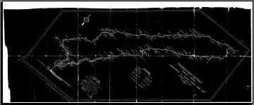
The map lists the following personnel:
F.E. Williamson............. Sports Man
R.L. Sturgis................... Sports Man
Emile (Mel) Cote........... Head Guide + Chef
Charlie Blue................... Guide + Hunter
Michael LeGard............. Indian Guide
Lindsay Vanderbeck ..... Motor Boat Captain
Louis LeGard................. Motor Boat Crew
James Vanderbeck......... Star Boarder
R.L. Vanderbeck............ Outfitter
To view the map in your browser, left-click the link above. It
will launch in a new window. To return to this page, just close that
window.
To download the map to your hard drive, right-click the link and select 'Save
as.'
(If it
doesn't display when you click the link, download the free Adobe
Acrobat Reader.) Many thanks to Bill and Lois Hoff for
providing Russ with the original map and to Russ for providing this scan.
|
|
|
Google™ Maps View of the Nakina AreaNakina,
Ontario and Surrounding Area
This link launches a view of the Nakina area on the Google™ Maps site
in a separate browser window. The link goes to a hybrid view, which is an
aerial photo with map nomenclature overlaid onto it. You can switch
between map, aerial photo and hybrid views by using the buttons in the top
right corner. Use the slider in the top right corner to zoom in and out.
Click anywhere on the view and drag it around to see surrounding areas.
How close you can zoom varies depending on the quality of the pictures
available. Map nomenclature changes depending on how close you zoom in.
The Google Maps site is great!
|
|
|
Current
Topographic Maps
| Fedmaps
web site |
You can order current topographic maps of the Nakina - Wababimiga Lake
area from Federal Maps, Inc. (Fedmaps web site). The table below shows
which maps cover the area:
| NTS Number |
Title |
Scale |
Description |
| 42 L |
Nakina, Ontario |
1: 250,000 |
Nakina, Wababimiga Lake, and the entire Vanderbeck
trapping territory. Includes all lakes and rivers mentioned in the
book and on the book map. |
| 42 L/2 |
Nakina, Ontario |
1:50,000 |
Detail of Nakina, Nakina Airport, and most of
the southwest 3/4 of Cordingley Lake. |
| 42 L/7 |
Nakina, Ontario |
1:50,000 |
Detail of northeast 1/4 of Cordingley Lake, Cammack
(Poplar) Lake, John Bill (Grave) Lake, and the beginning of the Squaw River
(before Squaw Lake). |
| 42 L/8 |
Nakina, Ontario |
1:50,000 |
Detail of Wababimiga Lake, Squaw Lake and River, and
surrounding lakes northeast to Allan (Porcupine) and Chatham (Whitefish)
Lakes, near the NE end of Jim's trapline. Detail of the Drowning
River too, Emile Cote's trapping territory. |
|
|
|
Current Names for Lakes and Rivers in the Book
Many of the lakes and rivers mentioned in Trap-Lines North and
shown on the map Meader drew have been renamed in the years after the book
was written. The table below shows the old and new names.
| Old Name |
New Name |
Features |
| Cordingley Lake |
(same) |
In Nakina. Start of Vanderbecks' canoe route
to their trapping country. Big Lindsay and Emile Cote
established their base camp for guiding here in the 1930s. |
| Esskagannega Lake |
Esnagami Lake |
Another large lake in Nakina. Vanderbecks led
canoe trips through this lake and river by the same name. |
| Esskagannega River |
Esnagami River |
(See above) |
| Cranberry River |
Squaw River |
River feeding from Cordingley Lake to Grave (Cammack)
Lake. Jim fell through the ice here and was saved by his dog
Bruno. |
| Poplar Lake |
Cammack Lake |
Between Cranberry (Squaw) River and Grave
(John Bill) Lake. Lindsay's main camp was here. |
| Grave Lake |
John Bill Lake |
Between Poplar (Cammack) and Squaw Lakes.
Lindsay had a trapline here. The nets they used for fish for
bait and feeding the dogs stretched across where Grave Lake
meets Squaw Lake. |
| Third Lake |
Part of Medugama Bay |
The chain of lakes between Poplar (Cammack)
Lake and High Hill Lake (route to Wababimiga Lake). Long Carry
portage is between this lake and High Hill Lake. |
| High Hill Lake |
|
Lake between Medugama Bay lake chain and a
line of hills just southwest of Lake Wababimiga. |
| Wababimiga Lake |
(same) |
Vanderbecks' winter cabin was on the bay near
the NE
corner. Jim took Meader there. Joe Leake's cabin was directly
N on the opposite shore. Big Lindsay and the girls ran
traplines around Wababimiga Lake. He had a cabin on the N
shore of the eastern tip. |
| Wababmimiga River |
(same) |
Flows west from Waba Lake, through a small
pond to meet the Drowning River. Big Lindsay ran a trapline on
the Waba River and had a cabin on a branch past the pond,
heading south. |
| Drowning River |
(same) |
Emile Cote's trapping grounds, east of the
Waba River. He considered it to be the most beautiful river in
the area. |
| |
Gaffney Lake |
The easternmost of two small lakes connected
to Porcupine (McEachern) Lake by Gaffney Creek. |
| |
Allan Lake |
Small lake between Gaffney and Porcupine (McEachern)
Lakes. |
| |
Gaffney Creek |
Connects Gaffney, Allen and Porcupine (McEachern)
Lakes. |
| Porcupine Lake |
McEachern Lake |
Southern reach of Jim's trapline. He had a
lean-to there. |
| Porcupine River |
Little Squaw River |
Part of Jim's trapline, running northwest from
Porcupine (McEachern) Lake. Jim had a camp on it almost
halfway between Porcupine Lake and the trail he took directly
north from the river to Beaver (Papoose) Lake. |
| Whitefish Lake |
Chatham Lake |
Northwest of Porcupine (McEachern) Lake. A trail
runs from Porcupine Lake through a small pond to Whitefish
Lake. A small stream runs from Porcupine Lake to that same
small pod. Part of Jim's trapline. Connected to Squaw Lake by a short
stream, but Jim used a trail slightly west of the stream to
reach Squaw River and his home camp there. |
| Beaver Lake |
Papoose Lake |
Between the Porcupine (Little Squaw) and
Squaw Rivers. Connects to Squaw River by a short trail running
northwest. Jim had a camp where that trail meets Beaver Lake. |
| Abosabi Lake |
Bodkin Lake |
Northernmost tip of Lindsay's trapline.
Connected to Jim's main camp by a stream. Connects to Loon
Lake to the west by a short trail. |
| Loon Lake |
|
Small lake between Abosabi (Bodkin) and
Sucker (Stairs) Lakes. Connected to Abosabi by a short trail,
and to Sucker Lake by a small stream. Lindsay's trapline. |
| Sucker Lake |
Stairs Lake |
SW of Sucker (Stairs) Lake. Connected to
Abosabi Lake by a small stream. Lindsay had a camp where that
stream met Sucker Lake. Connects to Squaw Lake by a stream and
two small ponds to the SE. Lindsay's trapline. |
| Squaw Lake |
(same) |
Ten mile lake starting connected to Grave
(John Bill) Lake, to the SW. Narrows to become the Squaw River in the NE.
Lindsay's trapline. |
| Squaw River |
(same) |
Runs NE from Squaw Lake. Jim's main camp was
on the northern shore of the river, across from where the
trail from Whitefish (Chatham) Lake meets it. The NE end of
his trapline ran up the river, past Beaver (Papoose) Lake. His
lower camp was seven miles before the end of the trapline
where the Squaw reaches the burnt land. |
|
|
|
Ontario Crown Land Use Map
This map of the Nakina, Wababimiga Lake area is provided by the Ontario
Ministry of Natural Resources. The current topographic maps listed above are better, but this map shows many of the features of the
Vanderbeck trapping territory. The map is in Adobe Acrobat (PDF) format so you'll
need the Adobe Acrobat Reader to view it. This map must be printed at 36" x 30" in
order to maintain scale of 1:100,000.
Click the first link to view or download the map from this web site. It
will launch in a new window. To return to this page, just close that
window.
Click the second link to launch the Ontario MNR web
site in a new window to view or download the map.
| Nakina Atlas map (1.8M)
| Crown
Land Use Atlas Web Site |
|
|
|
Drowning River Canoe Trip Log
Detailed log of a July 2004 canoe trip taken down the Drowning River by
Mr. Perry Jameson, in which he describes coming upon the remains of a
cabin started, but not finished, by Lindsay Vanderbeck Sr. Thanks, Russ, for
sharing this great find with us.
Click the link below to open this web page in a new window.
| Drowning
River Canoe Trip Log |
|